
Drone Documentation Projects San Francisco Bay Area
Sky Optix provides FAA-certified aerial documentation for construction, infrastructure, roofing, and agricultural clients across the San Francisco Bay Area. Below are examples of active and completed projects.
Trusted by:


Featured Project
Active Site
Featured Project Active Site
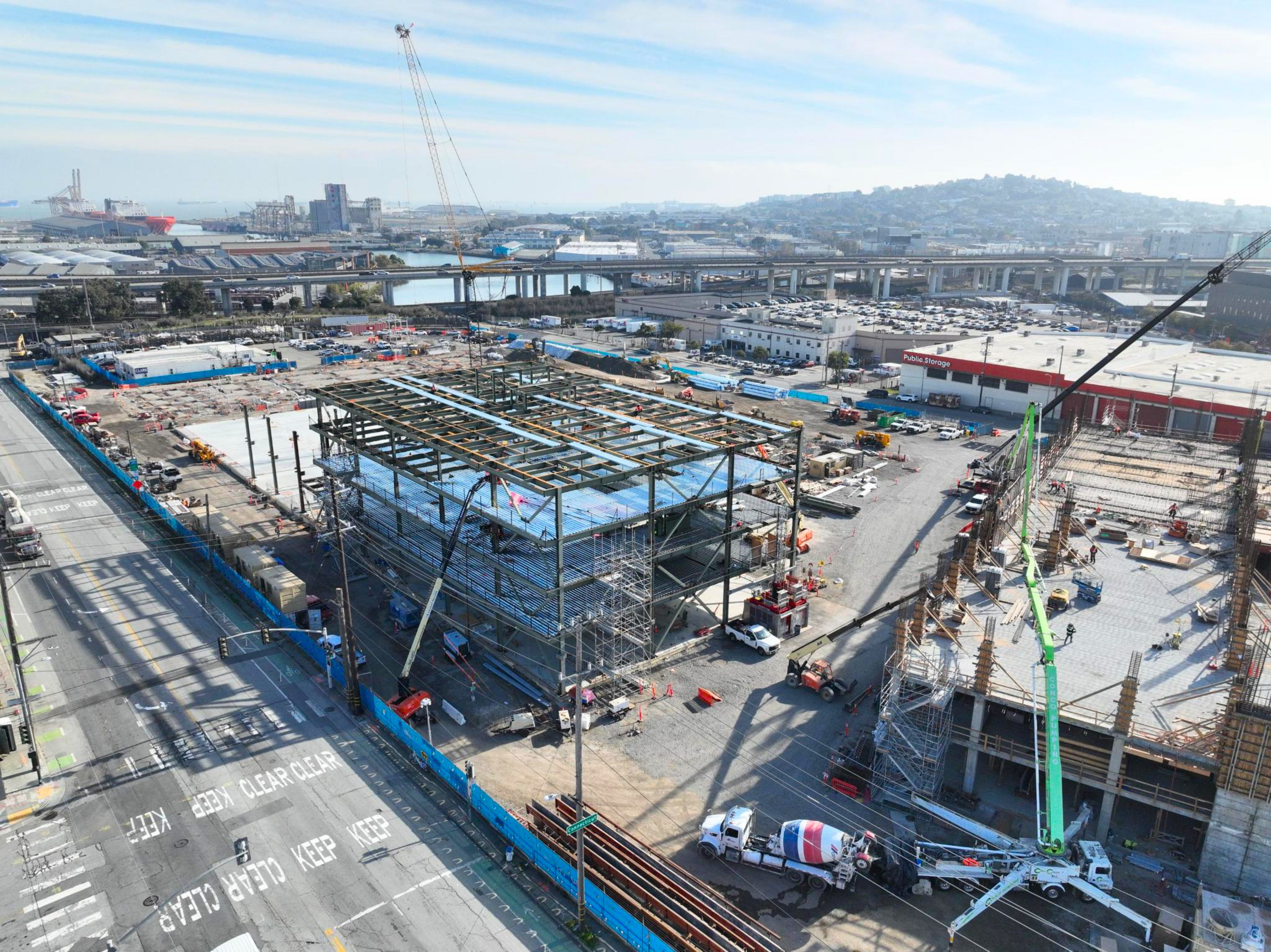
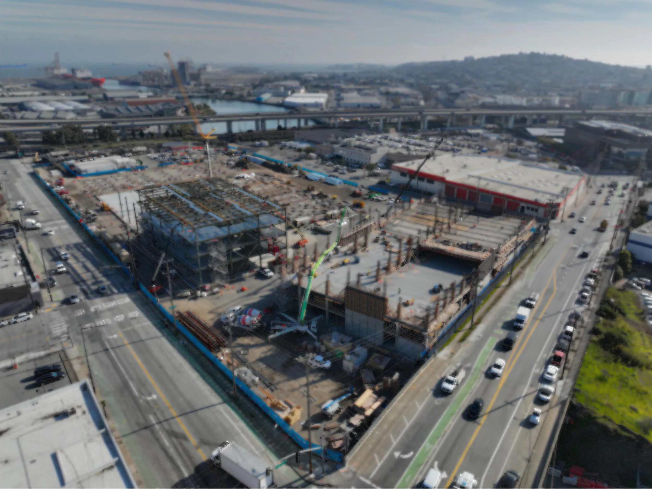
SFPUC Water Department Campus
Client: Clark Construction
Project Type: Public Infrastructure — Active Construction
Location: 2000 Marin Street, San Francisco, CA
Project Value: $428 million
Status: Active — ongoing documentation
-
The SFPUC Water Department Campus at 2000 Marin Street is one of San Francisco's most significant public infrastructure projects. The facility is designed to withstand a magnitude 7.8 earthquake and will manage over 1,250 miles of water mains while generating 900 kilowatts of renewable energy through integrated solar arrays. Construction is being managed by Clark Construction, one of the largest general contractors in the United States.
-
Sky Optix provides recurring drone-based construction progress documentation throughout the project lifecycle. Each flight captures consistent, high-resolution aerial imagery from predetermined positions and altitudes, allowing project stakeholders to compare site conditions across visits and track construction progress over time.
Deliverables include high-resolution edited aerial photos, 4K video overviews, and 2D orthomosaic maps. All assets are delivered via cloud link within 48 hours of each flight.
-
On a $428 million public infrastructure project with multiple subcontractors, phased construction sequences, and ongoing reporting obligations, accurate and repeatable site documentation is critical. Aerial imagery provides project managers, owners, and inspectors with a reliable visual record that supports payment applications, dispute resolution, and stakeholder reporting — without requiring additional site visits or disrupting active construction operations.
Drone documentation also captures conditions that ground-level photography cannot — full site context, structural progress from above, and spatial relationships between systems and structures that are only visible from altitude.
Get a Free Aerial Site Capture!
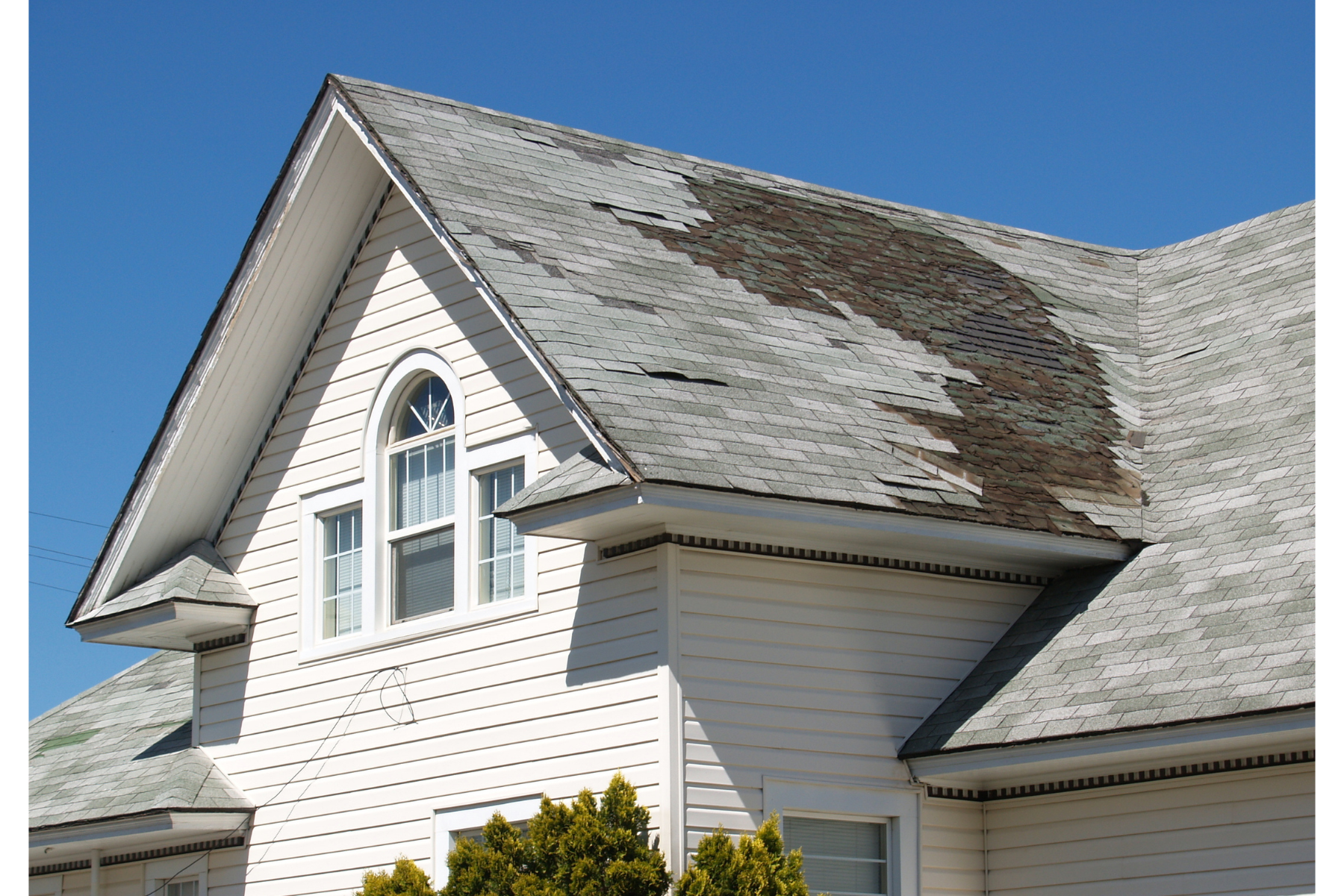
Roof Inspections – Marin County
Client: Residential properties (private)
Project Type: Roof Inspection
Location: Marin County, California
-
Sky Optix conducted drone roof inspections for residential properties across Marin County, delivering high-resolution aerial imagery and full-coverage video of each roof surface. Inspections covered all roof faces, ridgelines, valleys, flashing points, and drainage areas — capturing details that would require ladders, scaffolding, or lift equipment to access through traditional methods.
-
A drone roof inspection covers the entire roof in a single mobilization, typically in under an hour, with no equipment setup and no risk to personnel. For homeowners, the imagery provides clear documentation of existing conditions before filing an insurance claim or requesting a contractor estimate. For roofing contractors, drone inspection allows more properties to be assessed in a day, with detailed visual evidence that supports accurate scoping and builds trust with clients.
Deliverables included high-resolution inspection photos organized by roof section and key-angle coverage of areas of interest identified during the flight.
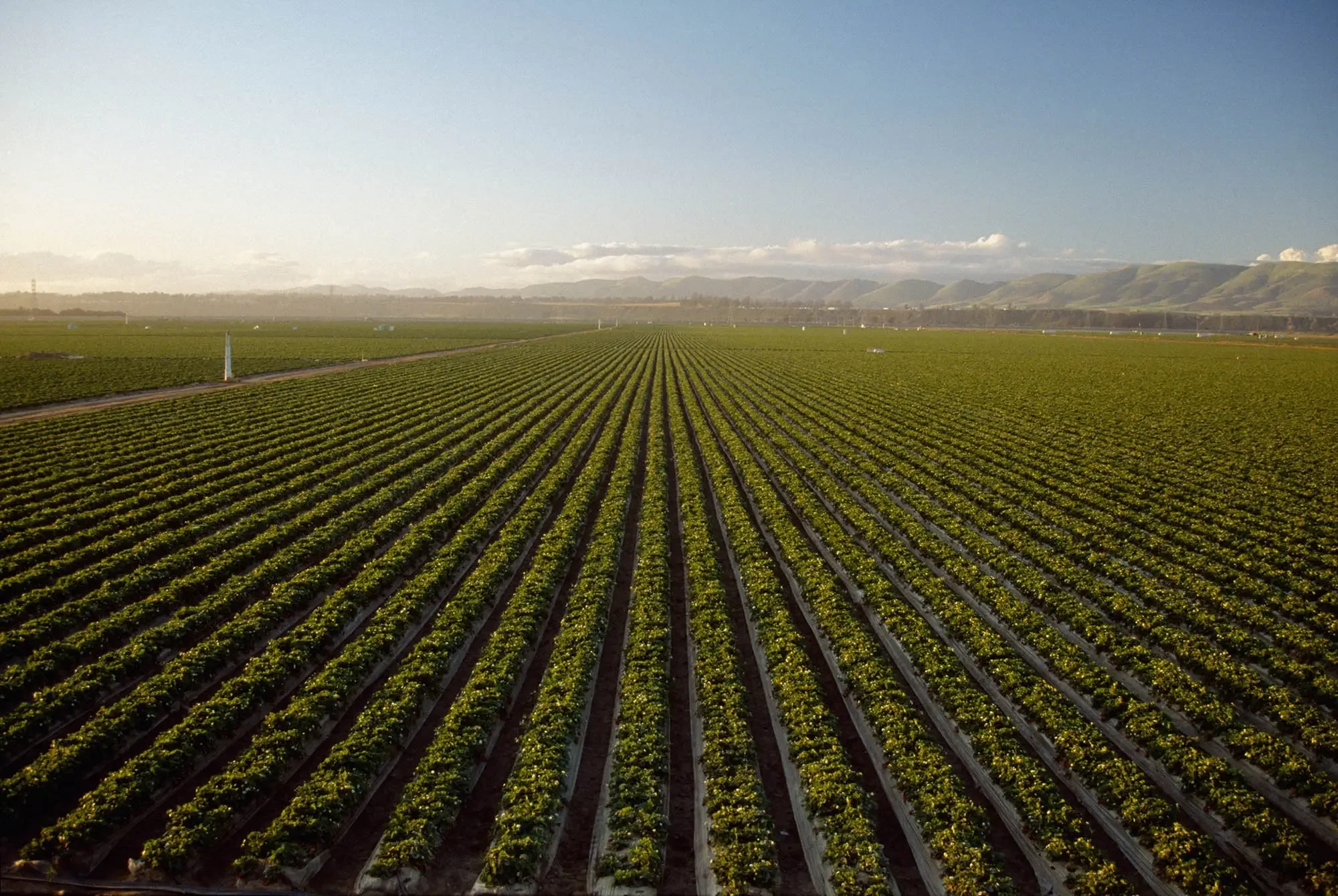
Land Surveys – Santa Cruz County Agriculture
Client: Driscoll’s (agricultural operations)
Project Type: Land Survey Documentation
Location: Santa Cruz County, California
-
Sky Optix conducted aerial survey operations for Driscoll's agricultural operations in Santa Cruz County, providing a comprehensive visual baseline of property conditions to support renovation and reconstruction planning.
Deliverables included a 2D orthomosaic map stitched from aerial imagery, full photo documentation of site conditions, and overview video footage of the renovated areas.
-
An orthomosaic map is a high-resolution, geometrically corrected aerial image stitched together from dozens or hundreds of individual drone photos. Unlike a standard aerial photo, an orthomosaic is spatially accurate — meaning distances, areas, and boundaries can be measured directly from the image. For agricultural and land survey applications, this provides a precise, scaled view of property conditions that supports planning, reporting, and contractor coordination.Deliverables included high-resolution inspection photos organized by roof section and key-angle coverage of areas of interest identified during the flight.
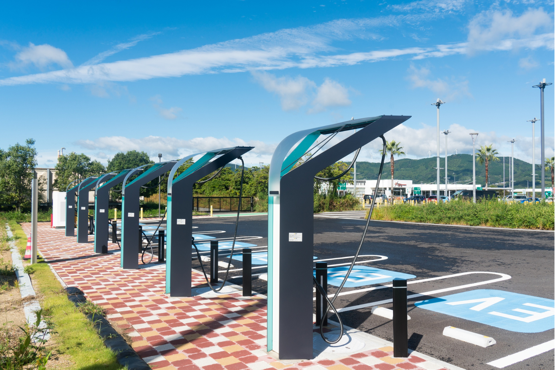
Insurance Inspections – EV Charging Infrastructure
Client: EVgo
Project Type: Insurance and Condition Documentation
Location: Multiple sites, Bay Area
-
Sky Optix conducted aerial documentation of EVgo's installed EV charging infrastructure across multiple Bay Area locations, providing consistent condition photography to support insurance documentation and asset management.
Deliverables included condition photos, facade and elevation captures from multiple angles, and site overview video for each location.
-
For companies managing assets across multiple locations, drone documentation provides a consistent, repeatable inspection format that scales efficiently. A drone operator can document site conditions, capture facade elevations, and record the surrounding environment in a single visit — producing standardized assets that can be compared across locations and revisited over time. This is particularly valuable for insurance documentation, where a clear and dated visual record of asset condition matters.
Accurate Aerial Documentation
·
Fast Turnaround Delivery
·
Clear, Actionable Visual Data
·
Accurate Aerial Documentation · Fast Turnaround Delivery · Clear, Actionable Visual Data ·
Deliverables
What Sky Optix Delivers
Every Sky Optix project produces professional-grade aerial assets delivered via cloud link within 48 hours. Deliverables are selected based on project type and client needs.
Deliverable
Interior FPV flythrough
3D digital twin models
Best For
High-resolution aerial photos
Aerial timelapse
2D orthomosaic maps
Documentation, reporting, site overviews
4K aerial video
Marketing, presentations, progress overviews
Project milestones, marketing, social media
Walkthroughs, listings, spatial documentation
Site measurement, planning, land surveys
360° panoramas
Remote review, structural documentation
Aerial site context, elevated vantage points
Every job begins with a site that needs visibility.
From active construction projects to completed properties and infrastructure inspections, professional aerial documentation provides the clarity required to plan, verify, and execute with precision.
LET’S GET STARTED
Our team is ready to provide the attention, care, and expertise you deserve.
CONSTRUCTION CAPTURE
Frequently Asked Questions
-
Construction progress documentation is a recurring service where a drone operator flies a job site at regular intervals — weekly, biweekly, or monthly — and captures consistent aerial imagery from the same positions and altitudes each visit. The result is a visual timeline of the project from above, showing how the site has changed from groundbreaking through completion. General contractors, developers, and project managers use it to support stakeholder reporting, track subcontractor progress, document conditions for payment applications, and maintain a visual record throughout the build.
-
The right frequency depends on the pace of construction and the documentation requirements of the project. For fast-moving commercial or infrastructure builds, weekly flights are common — capturing meaningful change between visits and providing project managers with a current view of site conditions at all times. For slower-moving projects or those with monthly reporting requirements, biweekly or monthly flights are often sufficient. Sky Optix offers flexible retainer contracts that can be adjusted to match your project timeline.
-
Aerial construction documentation is used for a wide range of purposes on active job sites. Project managers use it for progress tracking and stakeholder reporting. Owners and developers use it to monitor work in place without requiring additional site visits. Contractors use it to document conditions before and after specific phases of work, supporting payment applications and protecting against disputes. Inspectors and safety managers use aerial imagery to review site conditions from above. And project teams use it for coordination — identifying sequencing issues, tracking material staging, and communicating conditions across teams working in different locations.
-
Yes. Sky Optix operates on active construction sites and coordinates directly with site supervisors to ensure safe and compliant flight operations. We are FAA Part 107 certified, carry appropriate insurance, and handle all required airspace authorizations before each flight. Clients do not need to manage the flight logistics — we handle site coordination and deliver completed assets remotely within 48 hours.
-
Pricing for construction documentation depends on site size, flight frequency, and the deliverables required. Single-visit documentation starts at a base rate, with ongoing retainer contracts available at discounted pricing for clients who need regular documentation throughout a project lifecycle. Contact Sky Optix directly for a project-specific quote — we respond within 24 hours. New clients can also request a free aerial site capture with no commitment required at skyoptix.io/freeaerialsitecapture.
-
A standard drone photo captures the site from a single position and altitude, providing a high-resolution view of the area within the camera frame. An orthomosaic map is assembled from dozens or hundreds of overlapping drone photos processed through photogrammetry software, producing a single, seamless, geometrically corrected aerial image of the entire site. Because the orthomosaic is spatially accurate, distances and areas can be measured directly from the image — making it useful for planning, quantity estimation, and documentation where precision matters. Sky Optix provides both standard aerial photography and orthomosaic mapping depending on project requirements.
-
Aerial imagery from drone documentation has been used in construction disputes, insurance claims, and legal proceedings as visual evidence of site conditions at a specific point in time. Sky Optix delivers all imagery with embedded metadata including date, time, and GPS coordinates. While admissibility depends on the specific jurisdiction and circumstances, a dated, GPS-tagged aerial record is generally considered stronger documentation than undated ground-level photography. Clients with specific evidentiary requirements should confirm their needs with legal counsel — Sky Optix can discuss documentation practices that support your requirements.
Sky Optix | Bay Area Drone Services | (707) 355-4489 | contact@skyoptix.io | skyoptix.io FAA Part 107 Certified | Serving Marin County, San Francisco, and the Bay Area